
Whatcom’s Olsen Creek Trail System boasts stunning forest, bay, mountain views and access for hikers, mountain bikers and horseback riders.
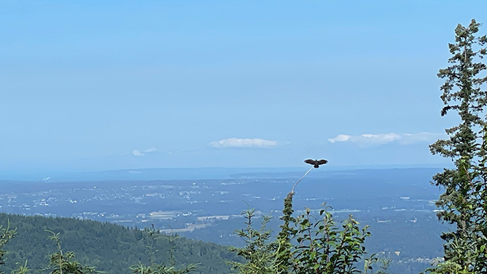
High above the new Lion’s Mane Trail on Stewart Mountain, a turkey vulture perches on the tip of a tree and spreads wide its wings, holding what’s known as a horaltic pose, possibly to warm itself or to rid its feathers of parasites such as lice.
Four of us are on the trail just east of Bellingham this Friday morning in July, and at first we think it’s an eagle, a big one. But a quick peek through binoculars reveals a telltale bald red head. The vulture launches into the dazzling blue sky. We keep walking.
The trail, named for an edible mushroom native to the Pacific Northwest, is above Lake Whatcom and is part of the new Olsen Creek Trail System formally opened in late June by the Washington State Department of Natural Resources, or DNR.
It adds roughly seven miles for hikers, mountain bikers and horseback riders in the newly formed Olsen Creek State Forest in Whatcom County.
The total project cost so far is about $950,000, including staff time; environmental analysis and mitigation; cultural resource evaluations and design, including of a 75-foot bridge that will cross Olsen Creek in the future, according to DNR.
It’s the start of what could be a more expansive trail system, provided state dollars continue to come through.
If the original proposal is fully funded and implemented, it will mean a total of 17 miles of DNR designated trails in the forest and connections to trail systems on adjacent public lands, such as those managed by Whatcom County Parks & Recreation as well as the Whatcom Land Trust, according to Mike McKenzie, DNR’s acting recreation manager for the Baker District.
Before the trail system went in, DNR had 2 miles of designated trails in Whatcom County – on a piece of land on Galbraith Mountain near Bellingham. This addition helps meet ongoing demands for recreation on DNR land and protects wildlife and sensitive areas, such as Lake Whatcom, from harm caused by unsanctioned use, the state agency said.
For now, the trail system is new enough that DNR hasn’t yet published trail maps on the recreation page of its website. But such maps are up at a number of checkpoints on the routes.
Wildflowers — and a bear
We park at the Y Road Trailhead, walk down a wide graveled path to Checkpoint Charlie and stop to study the posted map before veering left for the start of Hedgehog Trail. The elevation here is about 560 feet and our goal is the top of the Lion’s Mane Trail at 2,000 feet, which is the trail system’s highest point — for now.

The hike takes us on a steady climb on wider roads and single-track dirt paths with wildflowers crowding in from both sides. Up and up, we amble through groves of trees, walk over banana slugs and admire pink-purple fireweed, white daisies and stands of white, pink and purple foxgloves.
Along the way we meet a runner who asks if we’ve seen a bear. We haven’t. The bear was down at the Hedgehog Trail and a woman’s dog scared it off, he said.
At two viewpoints, including at the top of Lion’s Main — reached soon after passing Checkpoint Hello – we see Bellingham Bay, Lake Whatcom and Agate Bay. Parts of Bellingham spread out below us; in front of us are mountains with snow still on them.
After oohing and aahing, we head back down the mountain to the parking lot — for a trek totaling about 7.9 miles.
‘Aren’t seen from other recreation sites’
Volunteers marshaled by advocacy groups the Washington Trails Association, Whatcom Mountain Bike Coalition and the Whatcom Chapter of Backcountry Horsemen of Washington worked with DNR to help build the new routes.
The Olsen Creek Trail System is a combination of new trail construction, renovating and improving existing user-built trails and closing selected user-built trails, according to DNR’s McKenzie.
WTA has put an estimated 4,000 volunteer hours into the project since late 2022, according to Arlen Bogaards, Northwest Regional manager for the trails association.
He said the new routes offer new vistas.
“With this trail system sited in and traveling through a working forest, the different ages of stands and the characteristics of the forest are interesting to observe,” Bogaards said. “There are some interesting viewscapes that reveal themselves that aren’t seen from other recreation sites.
“Views of Squalicum Lake and distant Canadian peaks are pretty cool looking over the farmland in the north county,” he said.
By law, DNR must manage its working forests to generate revenue, including through logging, for schools, hospital districts and other designated beneficiaries.
Outdoor lovers will find more options than an out-and-back trek.
“The trail system was designed to offer several stacked loops, allowing trail users to choose from a variety of routes that may incorporate both the developed trail system and the existing road system that is also used for forest management activities,” McKenzie said.

Mountain bikers riding downhill are diverted to different routes.
Both downhill mountain bike trails — Earth Star and Turkey Tail, also named after mushrooms — are rated as difficult for “challenging terrain with relatively moderate grades and variable trail surfaces,” McKenzie said.
“Riders should expect to encounter some unavoidable larger obstacles and technical features,” he added.
As for the next phase of the trail system’s development, that is expected to happen June 1 to Sept. 30, 2026, when DNR intends to begin work on the south side of Olsen Creek, including building the 75-foot bridge across the creek.
If you go
Trailhead parking: For now, access to the Olsen Creek Trail System is at the Y Road Trailhead managed by Whatcom County Parks and Recreation, so a Discover Pass isn’t required.
Share the lot: Because parking is limited, pay attention to signs that indicate parking reserved for horse trailers, avoid blocking gates, and park so as to minimize wasted space between vehicles.
You should know: There’s no restroom at the trailhead.
— By Kie Relyea
Also read in Salish Current:
• “Leveling the playing field with accessible activities,” July 14, 2025
• “Bellingham adds 66 acres to Samish Crest green space,” April 8, 2025
• “Trail guide: Ptarmigan Ridge,” Aug. 22, 2024
• “The roadblock that’s limiting visits to a Whatcom ‘treasure’,” Aug. 5, 2024